| 解説France1911dev.png |
Four inset maps of the historical development of France:
- "FRANCE at the end of the 10th. Century",
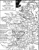
- "FRANCE in the 13th. Century",
- "FRANCE in the 14th. Century", and
- "FRANCE: The Eastern Frontier, 1598–1789".
Details include "Royal Domain in 987", "Fiefs of the Crown", "Navarre under Sancho the Great, 1000–1035", "Boundary of Lands nominally allowed to the English King, Henry III by the Treaty of Paris 1259", "Royal Domain in 1180", "Acquisitions under Philip Augustus, 1180–1223", "Acquisitions under Louis VIII, 1223–1226, & Louis IX, 1226–1270", "Acquisitions under Philip III, 1270–1285, & Philip IV, 1285–1314", "English King's Lands in 1328", "English King's Lands after the Treaties of Brétigny & Calais, 1360", "Royal Domain in 1328", "Acquisitions under Philip VI and John II, 1328–80", "Frontier after the Treaty of Veruins [Vervins], 1598", "Acquisitions under Henry IV, 1598–1610", "Acquisitions under Louis XIII, 1610–43", "Acquisitions by the Treaty of Westphalia, 1648", "Acquisitions by the Peace of the Pyrenees, 1659", "Acquisitions 1661–1662", "Acquisitions by the Treaty of Aix la Chapelle, 1668", "The 10 Imperial Cities in Alsace incorporated in 1672", "Acquisitions by the Peace of Nijmwegen 1678–1679", "Various Acquisitions (Réunions) till 1697", "Acquisitions 1697–1715", "Acquisitions under Louis XV, 1715–74", "Dates of Acquisition", "Dates of Losses".
Also included: Philip II of France, Treaty of Paris 1259, Henry III of England, Louis VIII of France, Louis IX of France, Philip III of France, Philip IV of France, Philip VI of France, John II of France, Charles V of France, Treaty of Brétigny, Henry IV of France, Louis XIII of France, Peace of Westphalia, Treaty of Aix-la-Chapelle (1668), Louis XV of France, Alsace, Roussillon, Savoie, Switzerland, Franche-Comté, Flanders, Lorraine, Bar, Languedoc, Burgundy, Champagne, Bretagne, Poitou, Navarre, Anjou, Auvergne, Gascogne, Quercy, Aquitaine, Marca Hispanica, Aragon, Gothic March, Normandy, Berry, Foix, Treaty of Vervins, Peace of Nijmegen, Treaty of the Pyrenees |


